The washouts and mud slides that I saw are between Mile 3.8 and Mile 4.8. I'm not aware of any others, although there may be some. If you have any information, please let me know. (All mileages are approximate.)
Disclaimers
First the usual disclaimer. The comments in this blog are mine and mine alone. If you have any information that will correct anything I have said, please let me know and I will try to reflect your information in this post. I am not a civil or soils engineer. My observations are based on what I saw, mixed in with a bit of experience in road construction, excavation work, and a general knowledge of construction techniques. Nothing in this post should be taken as blaming anyone for what happened. It was an act of nature and these things happen. If you use any of this information in making any engineering decisions (not that you will), you assume complete responsibility for the use of this information, including any consequences that may result.
The Soil Conditions
You first have to understand that the terrain between Mile 3.8 and 4.8 is composed of clay mixed in with pockets of sand and gravel. There's a steep 2% climb in elevation as the track tries to escape the Ottawa River plain through a series of S-curves. The area is pocketed with deep ravines covered in trees and bush with the track going across these ravines on high clay fills. Add some water to the clay soils and you have the potential for washouts and mudslides. The area has a long history of mud slides and washouts. Last Spring was no exception.
To focus our bearings, here's satellite map of the area that we visited. Like I said, all mileages are approximate but this will give you an idea of where the problem areas are located.

Mile 3.8 - Two Washouts - The Embankments Kicked Out At The Bottom
Coming up from the south, the track at Mile 3.8 goes across a deep ravine on a long clay fill. Once the track gets across the North side of a clay fill, it enters a clay cut that goes North and uphill on a 2% grade for a distance of about half a mile. Drainage through this clay cut isn't the best as the ditches and culverts are undersized to carry off even the Spring runoff. This time, with the heavy rains this Spring, the water rushed down the ditches on the East side of the tracks.
A culverted ditch on the East side got plugged up with debris and the water rose over the tracks and across to the ditch on the west side. The ballast is loaded with clay, top soil and other materials that inhibits drainage away from the tracks. So the rails provided a nice water chute down towards the ravine. On reaching the ravine, the water shot out of the end of the ditch and down into the bottom of the gully. This action kicked out the bottom of the fill, taking a good part of the roadbed with it. Clay has a bad habit of doing that.
The water between the rails continued almost to the other side of the fill before it washed out another part of the roadbed carrying the supporting embankment with it.

Mile 3.8 is one of the two worst spots of the washouts simply due to the depth of the ravines and the amount of work that would have to be done to rebuild the embankments to support the track. This would require a lot of rock cages, assuming the clay soils can support the weight, and a lot of fill. There's no easy way to bring in truckloads of fill so this would be a job that could be very labour intensive.
Let's take a closer look at the 1st washout. Here's a photo that was taken last Spring shortly after the washout occurred.


It's all very do-able - but only if you have the right equipment. And a lot of labour. The first thing would be to stabilize the embankment with something like rock cages (assuming the clay base could hold the weight of the rock cages) and then rebuilding the embankment back up to the roadbed, compacting the fill as you go. In any event, the embankment needs to be stabilized.
Mile 3.9 - Washout Under The Tracks
Just around the corner from the two washouts at Mile 3.9 is another washout. This one would be very easy to fix. There's a moderate embankment that goes across a shallow ravine with a fast-flowing small creek flowing through a concrete culvert.


As shown in a photo taken last Spring, there's been some attempts at fixing the washout. It looks as if a new culvert was set in place and some ballast and rip-rap dumped in the hole. The work looks as if it's stabilized the roadbed and it would take a minimal amount of work to finish the job. Easy enough for volunteers and a few pieces of equipment to do.


In addition to having to deal with the water flow from the creek, the 1,500' of culverted drain on the East side discharges into the creek at a 90 degree angle, thus churning up the bank of the creek. It may be case that the drain may have to be re-routed underneath the tracks so that it discharges into the West side of the creek rather than the East side. Another alternative might be to add some culverts about every 500' to drain the water from the east side to the west side of the track, making use of the ditch on the west side. The ballast doesn't provide good drainage as it is loaded with topsoil and clay. So an alternate solution to culverts would be to remove the old ballast and add some new clean ballast. A very labour intensive job - just the right kind of thing for a gang of volunteers.
Finishing up this job would be very easy to do. Some fill, compaction, a bit more ballast, clean out the ditches and it would be ready for trains. Some volunteers, a hy-rail dump truck with some ballast or B-gravel, and it could be fixed quite easily. At the same time, clean out the ditches and creek with debris. Access would be from Loretta St. Correcting the discharge from the 1,500' drain would be in the long term.
Washout Mile 4.1
The washout at Mile 4.1 is due to fill for a level crossing filling up the ditch. Except for some ATVers, the level crossing hasn't seen traffic in a few decades. The track is still on an uphill grade with the water running down the east side of the ditch until it hits the level crossing. Taking the path of least resistance, the water went around the filled-in ditch which just happened to be the roadbed of the track.


Rip-Rap Mile 4.2
Holy crap, Batman! What happened here!!?? Just around the corner from the washout at Mile 4.1 we came upon work that had been done some years before. Looks as if it was a combination mudslide and washout - mud slide on the east side and washout on the west side of the tracks. All of the mudslide had been excavated way back from the tracks, the side of the hill filled with rip-rap, and the top planted in sumacs and evergreens. I would add some fast-growing grasses to keep the soils in place until the trees matured enough to provide a strong root system.
On the west side, the rip-rap goes all the way down the slope into the deep ravine.

Mud Slide Mile 4.4
At Mile 4.4 you have an example of what happens when Mother Nature mixes clay with water - a mud slide, complete with trees. The embankment simply let loose and slid across the tracks. The solution to this one is also very easy. Bring in a hy-rail rubber-tired power shovel and a hy-rail dump truck. Start digging the dirt off the tracks until the loose clay is completely removed. Here's what it looks like facing north (towards Wakefield)


Washout Mile 4.5
The washout at Mile 4.5 is an example of what happens when a culvert fails. The segmented concrete culvert was installed decades ago. It appears to be typical Canadian Pacific concrete pipe. Due to a combination of an undersized culvert and accumulated debris within the culvert, it seems as if the water decided to take a shortcut through one or more of the concrete segments. You can see in the photo below where the water leaked through a joint and then took out the side of the fill.


Washout Mile 4.6
And now we come to one of the fun parts in the reconstruction program - the washout at Mile 4.6. The roadbed has completely disappeared. The track is hanging in mid-air. The slope on the west side has completely washed out. What clay there was on the east side has completely gone.


This is going to require a major rebuild of the slope on the west side with rock cages, installation of properly sized culverts to drain water from the east side, and rip-rapping the fill on the east side, to say nothing of new ballast underneath and between the rails. Once that's done, there's the challenge of raising the tracks to the proper level - ballast tamper, ballast regulator and lots of ballast and B-gravel to get it to the proper height.

Either way, it's going to take a lot of work, although it's possible to work it from both ends - assuming that the problems between Mile 4.0 and here get resolved first.

Mud Slide Mile 4.7
There's a "small" mud slide on the east side of the tracks at Mile 4.7. Nothing serious, very easy to fix. If you had a bunch of shovels, lorries, wheelbarrows, it wouldn't take much to clean this one up. If I were arranging a gang of volunteers, this would be one of the first jobs I would tackle. Very manageable. Access is from the road at Mile 4.4. Here's the view looking north.


Washout Mile 4.8
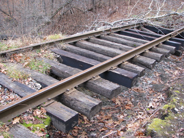
Another washout on the west side of the embankment at Mile 4.8. You can see how CP Rail fixed things up with a couple of old ties and some boiler tube. The slope at the lower reaches would have to be stabilized with rock cages.

So that's the end of our tour on the Hull Chelsea & Wakefield. If you have any additional information, I'd be interested in hearing from you.
Postscript - What's a Rubber-Tired Hy-Rail Power Shovel?
In case you were wondering what a rubber-tired hy-rail power shovel (excavator) looks like, here's a YouTube video. The operator isn't the most elegant but then it ain't easy putting one of these things on the tracks. But you get the idea. The equipment on the end of the boom is a brush-cutter.
If I didn't know better, that equipment looks as if it's Tim Lane's Sersa Total Track Maintenance from Mallorytown. Done a fair bit of sidewalk-superintending with those guys. Good crew!


1 comment:
Looks like there is lots of work to be done, but it will be more than worthwhile to get the HCWRwy running again. Looking forward to my first trip back up to Wakefield.
Post a Comment